Thursday, January 31, 2013

Trail Extension to Addicks Dam and West to Highway 6 (Jan 2013 construction pic update)


NEW COMMUTING OPTION FOR ENERGY CORRIDOR 
BICYCLE RIDERS IN THE WORKS

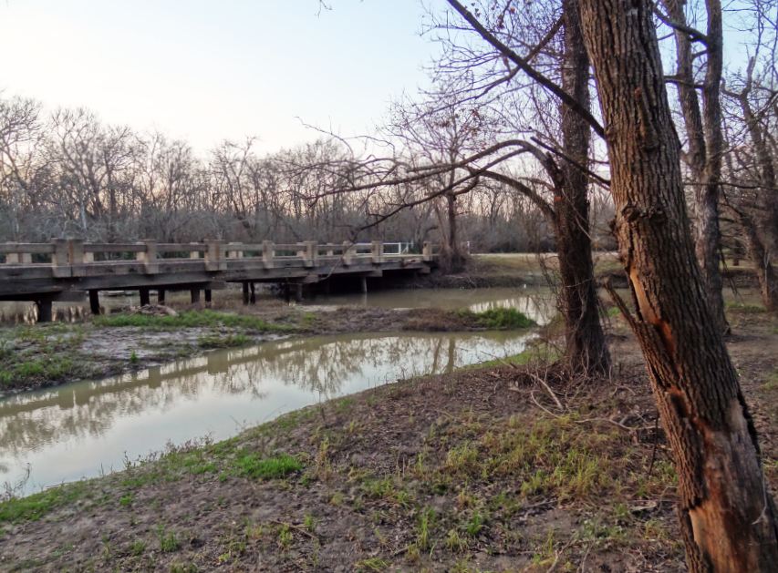
Construction work continues on the extension of the Terry Hershey Trail system to connect to the Addicks Dam Road, or rather to a new hike and bike trail being built at the base of the Southern (outside) slope of the dam that will continue on westward to Highway 6, and will provide a new route for bike commuters to  and from corporate campuses and energy corridor office buildings.

Here are a few pics taken this month (January 2013) illustrating the status of ongoing earth-moving and construction activity at various points between Terry Hershey Park / Memorial Loop Trail and Addicks Dam, including a panoramic view of the scene at the flow control gate where the reservoir empties into Langham Creek.  


Langham Creek


Ped-Bike bridge over Langham Creek at Terry Hershey Park

The water of Langham Creek through the year
different colors, different appearance
Langham Creek through spider web on bridge railing


Tuesday, January 29, 2013

Bike Trails in the Energy Corridor (photos)


Red stylized metal cyclist marking bike path
in the Energy Corridor near Eldridge Oaks
Bikers on the Northern segment of Barker Dam Road
North-South bike route through George Bush Park
(formerly Barker-Clodine Road, now closed to traffic)
Cyclist passing bird sitting on top of tree crown in George Bush Park
Bike Way sign alongside Eldridge Parkway near Kendall Library

Sunday, January 27, 2013

Road-sign with bullet holes


Wild West on the edge of H-Town .... This road sign apparently served as a target for informal shooting practice (even though a legit shooting range with dirt mounds to absorb bullets and security perimeter is located nearby at Westheimer Parkway).

Spooky Road Closed sign on Barker-Clodine Trail in the twilight
It is perforated by bullet holes


Palmetto in the wetlands


Palmetto sign in its typical habitat
Palmetto is an indicator plant found in wetlands areas, here at a ditch feeding into Buffalo Bayou inside George Bush Park

Palmetto bush on banks of a watercourse that periodically swells to  flood the surrounding wetlands area

The Houston Arboretum and Nature Center features an educational trail dubbed Palmetto Multi-sensory Trail. It explains the significance of the palmetto plant, and many other plants and trees.

Palmetto Trail  Information poster at wooden display with roof

Saturday, January 26, 2013

Why George Bush Park?


How did Bush Park get its name? It's not the bushes, no. Just one Bush, with capital letter. The elder. 


A poster in the section of the park South of Westheimer Parkway explains the role of former president George H.W. Bush -- along with Terry Hershey (for whom the park along the bayou is named) -- in preserving natural habitat and preventing Buffalo Bayou from being channelized -- i.e. straightened and its banks lined with concrete -- like other bayous in the greater Houston area.  


George Bush Park Map with trails and facilities shown (click to enlarge)

The 41st President of the United States is also being honored elsewhere in the City of Houston. Downtown, there is a George Bush Monument that has him (or rather a statute of him) looking over the Bayou, and there is also a Presidential Grove at Memorial Park. Current President Obama has a mural of his image in Midtown near the Breakfast Club restaurant, but it has been defaced already several times, and had to be redone by the artist. 


George Herbert Walker Bush Memorial


Friday, January 25, 2013

Playground at George Bush Park (South Barker Cypress Blvd)

George Bush Park signage with blooming shrub in July (2014 pic)

Playground equipment at George Bush Park South of Westheimer Parkway
Kites stuck in solitary tree on the open prairie land East of playground and pavilions
Pavilions available for  family gatherings and fiestas
by reservation

Wednesday, January 23, 2013

More Bicycles than Horses - Equestrian Area in George Bush Park (access from Westheimer Parkway)


The equestrian area of George Bush Park is not only for riders with horses. It's a good staging ground for bike riders too. As a matter of fact, the cyclists are far more numerous -- and regularly so -- than the horse-back riders. 

Directional sign to Equestrian Area parking lot
Dead-end access road from Westheimer Parkway going North
(South Barker-Cypress Road)

The parking lot at the equestrian trail section of Bush Park (technically South Barker Cypress and Beeler Rd., but who would have known) has a dedicated parking area for trailers, but also general parking, and provides access for hikers and bikers to (1) the North-South Bush Park Hike and Bike Trail (formerly Barker-Clodine Road, still paved, at least a width of a few feet); (2) the Noble Road Trail, which branches off Barker-Coldine to the East (only good for hiking and dirt-biking if not flooded); and (3) the paved trail to the soccer/rugby fields farther to the West. 
Westbound Trail
East-bound Trail,, which curves to left (North) behind the gate
Both trails cross over Buffalo Bayou, which comes in from the Southwest and meanders through the entire reservoir on its why to the flow-control gate at Barker Dam


Only circumstantial evidence of horse presence
on the day I took these pics
The portion of the East-West trail crossing the Bayou consists not only of a ped-bike bridge over the watercourse itself, but a much longer elevated wooden boardwalk over the riparian wilderness left and right of the bayou (which of course surges over its banks periodically, and creates a pretty wild scene with log-jammed driftwood and whatever comes downstream after heavy rails). Horses are not allowed on the boardwalk. It's peds and bikers only. Okay, I suppose kids in strollers too, but those types of non-motorized parent-powered vehicles are typically not specifically mentioned (or shown on signs). 


The paved North-South bike trail also crosses Buffalo Bayou, -- over a concrete street bridge, albeit one no longer used for motor traffic except county maintenance vehicles. 


Caution: As of Jan 2013, part of the railing is missing on the East side. Could a drunk driver have made it all the way in here and taken out the concrete pillar? Hard to believe, although it looks like the results of an accident of that sort. Perhaps a large tree fell on it. Who knows. 


Location of access road to Equestrian Area in George Bush Park shown on map
George Bush Park on the Map - Access to Equestrian Area from Westheimer Parkway
Here are a few more current pics to give you an idea what it looks like (in January) in the equestrian area and around the trails that originate there. 

Red winter berries on Beeler Road
Access road (with gate) to the paved trail to North-South bike route
(Barker-Clodine Road
One of Commission Radack's ubiquitous signs at George Bush trailhead
access point to North-South bike trail and Noble Road Trail,
which branches off of it, and turns North-East
to ultimately connect to the Barker Dam Road and the parking lot at Briar Forest.
Palmetto on the edge of the wooded area
Southern end of North-South bike route in George Bush Park
What's still green this early in the year (January) is the sign.
The grass shows various (off) colors depending on weather conditions
and lighting; suffice it to say green patches are scarce.
See earlier post and pics with North-South bike trail in lush green surroundings in the summer.

Noble Road Trail in January
While the prairie grasslands-area West of the North-South Trail evokes images of paradise in Spring and Summer -- with an abundance of colorful flowers and butterflies -- now that the greenery is gone, the landscape is far more appealing when it is dark, or near dark, -- with the setting sun adding a few  marmolated hues to the horizon. Not to mention leafless trees patiently standing still for seasonal silhouette (and long-exposure night shots).