Showing posts with label drought-and-wildfire. Show all posts
Wednesday, February 27, 2013
Dirt road to oil well site in Barker Reservoir in winter
The Tim Miles Trail in Barker Reservoir
This is a side trail branching off from Noble Road Trail inside Barker Reservoir, running first south on the edge of the wetlands restoration area that was devastated by a wild fire in 2011, then turns West and ends at a fenced oil well site with a number of large tanks. This dirt road does not have a name; so I am identifying it by the name of the Oil Lease (Tim Miles) to which it leads. Unlike Noble Road Trail, which crosses the park and links up with the Barker-Clodine Road bike-hike trial, the Tim Miles Trail is a cul-de-sac that does not get much foot or bicycle traffic. The West Houston sunsets from the North-South section of the trail can be pretty awesome, though, rivaling the scenic sunsets on the lake right behind the Dam. While there is no water here most of the year, and thus no reflection of the setting sun, the charred tree trunks limbs make for a ghastly silhouette against the blue and orange evening sky. The wildfire raged here in the Fall of 2012 and effects are very much still present, especially in the winter when the greenery is gone.
Monday, December 10, 2012
Wednesday, November 7, 2012
Comeback of George Bush Park Wilderness after the 2011 Wildfire
Miles Lease gravel road inside George
Bush Park
Wetlands Restoration Area inside the Barker Reservoir
South of Noble Road Trail behind Barker Dam
This trail runs along the perimeter of the US Army Corps of Engineers officially designated Wetlands Restoration Area inside George Bush Park. It is essentially a cul-de-sac and even less traveled by humans than Noble Road Trail, from which it branches off at a right angle near the edges of the a lake to the North and the better known one to the South, which is visible from the top of the dam, has a number of benches and open meadow area along its shores.
The lake to the South of Noble Road is better known and more popular. No doubt because it is a great place for romantic sunsets, or just a place to watch great sunset without any romance, period.
There are some signs posted where the Tim Miles access trail branches off from Noble Road, but they are not all readily visible over the summer because of the more ample vegetation, except for the one that bans dogs (and their poop) from the grounds. (It’s all going down to Buffalo Bayou and on to the Bay via the Ship Channel).
Initially Tim Miles trail runs straight South and may have
connected in the past all the way down to Westheimer Parkway. Not sure. I would
not want to venture down there, lest I end up in the shooting range.
As of
today, the gravel road makes a sharp right turn at a 90 degree angle and
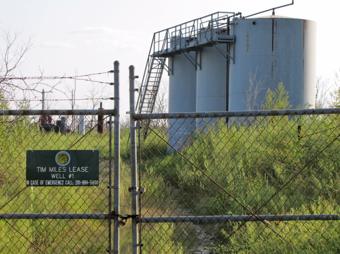
continues westward until it reaches the Tim Miles lease parcel, which is fenced
off and has a number of oil tanks in it, with metal rods sticking into the sky
on which birds occasionally roost.
Warning Sign elsewhere in George Bush Park |
Tim Miles Lease well site with oil tank |
In theory, you could continue to the West,
but if there ever was a road or trail there, it is now covered in chest-high
vegetation – at least during the warmer part of the year – and cannot really be
called a trail. I have not ventured beyond.
The trail is lined almost throughout its entire length by a trench running
North-South on the Eastern side, and one running West-East after the turn
(North of the trail).
These ditches fill with water after a good rain and are totally dry at other times. The segments of the Miles Lease Trail runs 
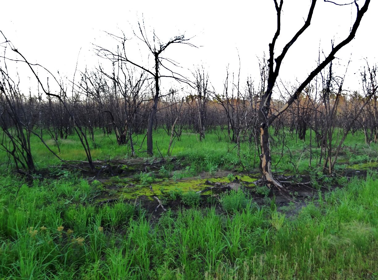
alongside what is designated a wetlands restoration area. This whole area was 
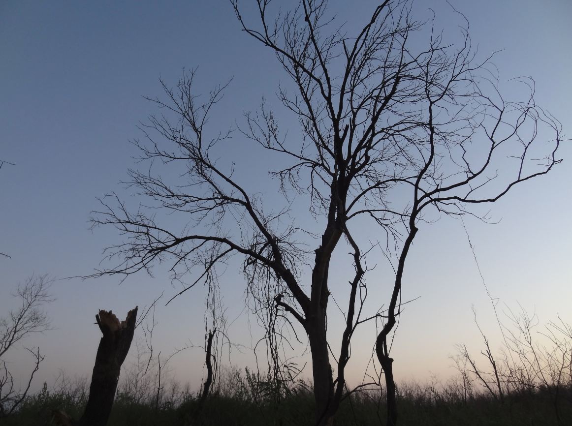
devastated by a large-scale bushfire in 2011.
All of the young trees on the open land are dead. Most still remain as charred skeletons. They create an eerie, yet inspiring, vista as the prairie grass and undergrowth is back is if nothing happened and furnishes a bed of green from which the charred trunks and branches jot up into the sky.
On a pretty day, this makes for a landscape in green, black,
and blue … and white … if there are some clouds too to complete the composition.
Gradually, the black deadwood is coming down during storms, and a few tree
limbs have fallen on the trail here and there.
When wet but not flooded, there will be puddles on the
gravel road and snakes may hang out near them, which is true of Noble Road trail
too. Watch your step. There are plenty of insects along the way. Of greatest
aesthetic appeal are the butterflies. The most common one seems to be the Gulf
Frittilary, which has different color and patterns on the upside and bottom
sides of its wings. The top side is almost solidly orange with a few specks,
the bottom side is white with more of a pattern.
Depending on the season, there
may also be Monarchs, Admirals, Buckeyes, and even Swallowtails.
Additionally, there are dragonflies
here too, as elsewhere in the area, but probably not as numerous as around the
lakes and waterholes unless the road-side ditch are flooded after heavy
rain. They like to hunt above the
surface and lay their eggs in shallow water.
Reddish (roseate) skimmer dragonfly |
Vegetation alongside the trail in Fall |
Overgrown access road to Tim Miles Lease oil well site inside Barker Reservoir |
Wednesday, October 17, 2012
Wildfire Aftermath - George Bush Park a year after the fire raged inside Barker Reservoir
A wildfire devastated large swaths of George Bush Park in West Houston a year ago, leaving a wasteland in its wake.
But nature is showing its resilience and has been re-greening the area from the bottom up, aided by much more frequent and abundant precipitation starting in January and through the remainder of the current year, causing the low-lying areas in the reservoir to fill with run-off several times already after heavy rain, including this week.
The grassland and bushes are back as if nothing had happened. The trees that were lost, however, will not be replaced as quickly. What's left of them -- charred skeletons sticking up into the sky -- provide an eerie reminder of the impact of last year's record-setting drought followed by large-scale fires.
Regreening of the meadow in the wetlands restoration area, but the trees singed by the wildfire in September 2011 are beyond recuperation |
Fungus growing on a charred tree trunk |
Landscape along Noble Road Trail inside Barker Reservoir |
Fungi at work helping decompose charred tree trunk |
Silhouette against evening sky of a burnt tree that remained leafless all summer and will eventually come down in a storm |
Orange-colored sunset glow behind a web of branches bare of leaves provides reminder of the bush fire that laid waste to this wooded area of Barker Reservoir a year ago |
Friday, September 14, 2012
When the wetlands aren't wet: Drought in the Reservoir
Gallery of nature pics taken in Barker Reservoir in hot & dry conditions in mid and late Summer. Compared to the extreme drought last year (2011), which also saw large swaths of grassland and trees in Bush Park turned to ashes by wildfire, there is still a lot of greenery this year. The areas shown were under water several times already this year. Look at the last picture from mid-July for comparison.
And this is how this part of the reservoir looked only a couple of months ago:
Reservoir grounds that are periodically inundated, but totally dry in this picture taken in September 2012 |
Dry creekbed turns into a trail |
Mud tower |
Wetlands area with a few green grass stalks |
Snail digging in as the bottom of the reservoir dries up |
Debris that prior floodings and water movement left in their wake |
Soil at low elevation spot in the reservoir shows cracks after drying up |
And this is how this part of the reservoir looked only a couple of months ago:
George Bush Park partially submerged in waters retained by Barker Dam after heavy rain (June 16, 2012) |
Subscribe to:
Posts (Atom)