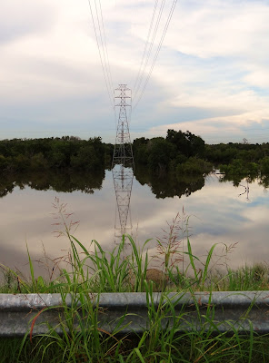
Anything but drought this summer: Rainwater flow-off from the Katy/Bear Creek area is draining to Addicks Reservoir and drowning the wilderness there, turning it into a huge lake, with a few trees sticking out here and there.
What a contrast with just a year ago!
 |
| Addicks Dam Gravel Road at Eldridge Parkway - Looking East (7/17/12) |
 |
| Area rainwater accumulating in South-East corner of Addicks Reservoir at Eldridge Parkway |
 |
| Terry Hershey Extension Trail Project Coming Soon Sign next to Eldridge Parkway on South side of earthen Addicks Dam |
 |
| Energy Corridor Office Buildings seen from the top of the Dam at Eldridge Pkwy |
 |
| Addicks Dam Road - Looking East (July 17, 2012) |
 |
| Detained Water at the Lanham Creek Flow Control Gate |
 |
| Looking down into the reservoir from the Addicks Dam Road near the Flow Control Gate: Electricity Pylon cum reflection (7/17/12) |
 |
| Addicks Reservoir in July 2012 - Built the The U.S. Army Corps of Engineers 80 or so years ago to protect Houston from flooding during spells of heavy precipitation |
 |
| Water flow control gate - Regulates water level in Langham Creek, a tributary of Buffalo Bayou |
 |
| Seasonal beauty with Energy Corridor Office Towers in the background |
 |
| Heading West on the Dam Road: Seasonal yellow flowers in large bushes with Water Tower near Highway 6 in the background |
 |
| Water Tower near Highway 6 close up against the cloudy sky |
 |
| Addicks reservoir grounds covered in several feet of water after mid-July storms - Photo taken from gravel road on the cusp of the dam |
No comments:
Post a Comment