Showing posts with label hiking-and-biking-in-West-Houston. Show all posts

Sunday, October 16, 2016

Addicks Dam Road and Hike and Bike Trail remains closed due to ongoing repair work


The Extension of the Terry Hershey Hike & Bike Trail North to Addicks Dam remains off limits for hikers and bikers as repair work continues at the outlet structure and elsewhere along the earthen dam, which has been rated righ-risk, but successfully held back record-breaking amounts of water during the heavy rains earlier in the year. The high water level in the reservoir led to the closure of both North Eldridge and Highway 6 for weeks, and turned Bear Creek Pioneers Park into a lake.   


 This stretch of North Eldridge behind the Dam was closed for weeks during the flooding 
earlier this year.


Hike & Bike Trail Closure - Terry Hershey Trail Extension to Addicks Dam
PEDESTRIANS AND BICYCLES PROHIBITED 

Wednesday, January 8, 2014

10 Mile speed limit for bicycle riders on multi-use hike-bike trail


Bicycle speed limit on paved multi-use trails in George Bush Park: 10 miles per hour when passing

Speed Limit posted outside Dam near Highway 6 and Briar Forest / Noble Road
10 MPH Speed Limite sign North of Shooting Center on Barker-Cloding segment of George Bush Park Trail


Friday, February 22, 2013

Terry Hershey Park and Trail ... and the Person


Photo of Terry Hershey, for whom the park
and trail is named
Both the Park (located north of Memorial Drive) and the trail system alongside both banks of Langham Creek and Buffalo Bayou are named after Terry Hershey, to honor her contributions to the preservation of this natural resource for the continued enjoyment by Houstonians and visitors. Both components (the contiguous park in the narrower sense, and the trails along the water-courses), are collectively referred to as Terry Hershey Park, which is somewhat confusing. The term "linear park" can also be found, which is a misnomer even for the hike-and-bike trail, for it is by no means straight. Anything but. It meanders, and the segment North of Memorial is actually a loop if you include the Memorial Drive road bridge over Langham Creek. 

The park North of Memorial Drive near the BP Office Tower (an area landmark with perennial circling vultures) features a playground, a kid-fit exercise areapavilions, and amenities such restrooms with running water, and drinking water fountain). 


Pavilion at Terry Hershey Park
Poster board for announcements - also has photo of Terry Hershey

A special attraction -- not to mention one of educational value -- is the ground-level sun dial that uses the shadow of the person wanting to know the time as a clock hand, with seasonal adjustments made for the month of the year.  Click the link in the preceding sentence if you want to know what such a sun clock is called. (The term would qualify for a spelling bee contest). 


Water fowl can be seen at Hershey Park throughout the year. In winter, large numbers of black-bellied whistling ducks can be observed at and on the pond that is part of the adjoining Exxon Chemical corporate campus to the West of the park (the corporate campus is not open to the public). There may be even more now since Skanska went ahead with its plan to drain the retention pond on the property across Memorial to the South, which it is re-developing for office use. 


The Terry Hershey trail system is designated "multi-use" and includes many ped-bike bridges along the way over Langham Creek, Buffalo Bayou, and tributaries/drainage channels. One of the pedestrians truss bridges is named for Jake Hershey, Terry's late husband, who was also a benefactor and nature and wildlife preservation activist. A big patch of blue bonnets on a slope closeby comes to bloom there every spring (in case you can't find the time to head out to Brenham to enjoy vistas of seas of Texas' official state flower the American way -- drive-by style). 

  
Caution is advised along the paved trails because of the "mixed use", i.e. the presence of both pedestrians and bicyclists. There is a posted speed limit for bikers (10 mph when passing), but it is routinely ignored. Some bikers do not use lights in the dark and pedestrians seldom do, if ever.   


A map of the trail system is posted at various locations, but Google Maps and Satellite view is more useful and convenient these days.


Tuesday, January 29, 2013

Bike Trails in the Energy Corridor (photos)


Red stylized metal cyclist marking bike path
in the Energy Corridor near Eldridge Oaks
Bikers on the Northern segment of Barker Dam Road
North-South bike route through George Bush Park
(formerly Barker-Clodine Road, now closed to traffic)
Cyclist passing bird sitting on top of tree crown in George Bush Park
Bike Way sign alongside Eldridge Parkway near Kendall Library

Wednesday, January 23, 2013

More Bicycles than Horses - Equestrian Area in George Bush Park (access from Westheimer Parkway)


The equestrian area of George Bush Park is not only for riders with horses. It's a good staging ground for bike riders too. As a matter of fact, the cyclists are far more numerous -- and regularly so -- than the horse-back riders. 

Directional sign to Equestrian Area parking lot
Dead-end access road from Westheimer Parkway going North
(South Barker-Cypress Road)

The parking lot at the equestrian trail section of Bush Park (technically South Barker Cypress and Beeler Rd., but who would have known) has a dedicated parking area for trailers, but also general parking, and provides access for hikers and bikers to (1) the North-South Bush Park Hike and Bike Trail (formerly Barker-Clodine Road, still paved, at least a width of a few feet); (2) the Noble Road Trail, which branches off Barker-Coldine to the East (only good for hiking and dirt-biking if not flooded); and (3) the paved trail to the soccer/rugby fields farther to the West. 
Westbound Trail
East-bound Trail,, which curves to left (North) behind the gate
Both trails cross over Buffalo Bayou, which comes in from the Southwest and meanders through the entire reservoir on its why to the flow-control gate at Barker Dam


Only circumstantial evidence of horse presence
on the day I took these pics
The portion of the East-West trail crossing the Bayou consists not only of a ped-bike bridge over the watercourse itself, but a much longer elevated wooden boardwalk over the riparian wilderness left and right of the bayou (which of course surges over its banks periodically, and creates a pretty wild scene with log-jammed driftwood and whatever comes downstream after heavy rails). Horses are not allowed on the boardwalk. It's peds and bikers only. Okay, I suppose kids in strollers too, but those types of non-motorized parent-powered vehicles are typically not specifically mentioned (or shown on signs). 


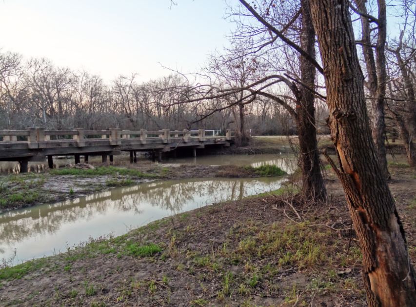
The paved North-South bike trail also crosses Buffalo Bayou, -- over a concrete street bridge, albeit one no longer used for motor traffic except county maintenance vehicles. 


Caution: As of Jan 2013, part of the railing is missing on the East side. Could a drunk driver have made it all the way in here and taken out the concrete pillar? Hard to believe, although it looks like the results of an accident of that sort. Perhaps a large tree fell on it. Who knows. 


Location of access road to Equestrian Area in George Bush Park shown on map
George Bush Park on the Map - Access to Equestrian Area from Westheimer Parkway
Here are a few more current pics to give you an idea what it looks like (in January) in the equestrian area and around the trails that originate there. 

Red winter berries on Beeler Road
Access road (with gate) to the paved trail to North-South bike route
(Barker-Clodine Road
One of Commission Radack's ubiquitous signs at George Bush trailhead
access point to North-South bike trail and Noble Road Trail,
which branches off of it, and turns North-East
to ultimately connect to the Barker Dam Road and the parking lot at Briar Forest.
Palmetto on the edge of the wooded area
Southern end of North-South bike route in George Bush Park
What's still green this early in the year (January) is the sign.
The grass shows various (off) colors depending on weather conditions
and lighting; suffice it to say green patches are scarce.
See earlier post and pics with North-South bike trail in lush green surroundings in the summer.

Noble Road Trail in January
While the prairie grasslands-area West of the North-South Trail evokes images of paradise in Spring and Summer -- with an abundance of colorful flowers and butterflies -- now that the greenery is gone, the landscape is far more appealing when it is dark, or near dark, -- with the setting sun adding a few  marmolated hues to the horizon. Not to mention leafless trees patiently standing still for seasonal silhouette (and long-exposure night shots).