Showing posts with label Barker-Cypress. Show all posts

Wednesday, November 30, 2016

Former site of Marks Ranch inside Barker Reservoir in 2016


Relocated Little Country Church 


LH7 Ranch Texas Historical Commission Marker 

Repurposed historic church 


Little country church on the prairie 

New residential development at Marks Ranch site 


Saturday, January 25, 2014

MARKS LH7 RANCH site raized to make way for residential development


The sun is setting on what used to be Marks Ranch (LH7 Ranch) in Barker, TX

LH7 Ranch site prior to Developers and construction equipment moving in
Church in background
LH7 Ranch Texas Historical Commission Marker
Barker TX (near Addicks and Clodine)
Excavation on ranch site to serve as detention pond for development nearby;
historical structures, including a church in the distance (Feb 2014 photo)
BELOW: Site of Marks Ranch as it looked before start of construction
with historical marker and old photos on poster

Marks Ranch historical site in Barker Texas, with interpretive markers

Kingsland Blvd. South of I-10 near Barker-Cypress Rd.
Satellite view of LH7 Marks Ranch site before new development. Ranch buildings still visible on this image. The church seen in the thumbnail pic has been moved closer to Barker-Clodine Road and is being preserved, along with a couple of other old buildings, including Barker Post Office and General Store


Sunday, January 13, 2013

New restaurant openings along Katy Freeway: Tony's, El Rancho, Food on Top of Golf

Margarita heaven after the cafe binge? 


Following a wave to new restaurant starts on Eldridge Parkway in 2012 -- predominantly cafes, the entrepreneurial frenzy seems to have shifted a little farther West toward Katy, with several new food and beverage operations on the way -- if not already completed -- on the North side of outbound I-10 past Highway 6.  

Tony's Mexican Restaurant - New Katy Freeway Location

Two more spots offering Mexican cuisine -- Tony's Mexican Restaurant and El Rancho - will enhance the South-of-the-border culinary panorama in this West Houston area that is currently seeing a construction boom that has dotted the horizon with cranes.  


El Rancho Mexican Restaurant north of Interstate 10 near Barker-Cypress


Not that the Energy Corridor does not already cater to Tex-Mex-craving palates with several existing establishments: 
    
Fiesta Sombrero's Grill y Cantina on Park Row, and two in the Grisby restaurant square in the SE corner of the Katy Freeway-Texas 6 interchange: Lupe Tortilla's  and Las Ventanas
not to mention the Poblanos Mexican Cafe farther South on Eldridge, and two on Memorial Drive: La Hacienda and Ninfa's Mexican Restaurant.

And then there is that gigantic new club swinger's paradise - TopGolf Houston. It's a golfing venue, alright, and a high-tech one at that, not to mention the enormous nets that have altered the skyline; but the newly erected leisure venue with landmark pretensions has food service as well to complement the fun, -- and drinks of course.

TopGolf frontal - Stairs leading up to entrance
TopGolf at Night - Drive-by-view of logo and lighted net posts from the Freeway


Saturday, January 5, 2013

Hatch Park Profile: Skatepark, Volleyball and Basketball Courts South of Katy Freeway near Barker-Cypress


Sergeant JR Hatch Park: 
More than just shaded green space with picnic tables. 

The Greater Houston Area boast numerous public parks, green spaces,  not to mention sports fields and facilities and venues for exercise. A number of municipal and county parks offer unique facilities and cater to the leisure-time and interests of diverse groups of residents and visitors.  


Sergeant J.R. Hatch Park is a Harris County Park [link to official county web page (updated June 2016)] located South of Katy Freeway near Barker-Cypress and adjacent to the much larger George Bush Park, just a bit North of the Western end of Barker Dam, which provides flood control by retaining the waters carried by Buffalo Bayou and its tributaries in case of heavy precipitation. 

Hatch Park Address: 17525 Katy Freeway, Houston, TX 77094 
Hatch Park's main attractions are a skate park, volley ball courts, and basketball hoops and corresponding markings in the parking lot on the Eastern edge of the small park, which seamlessly blends with the parking lot of Harris County Annex 13 / Constable Precinct facility. There are lots of police cars and other county vehicles on the lot, but park users are permitted to use it too.

Volleyball Courts
Basketball Hoop
In addition to the special sports facilities that distinguish it from other parks in the West Houston area, Sergeant Hatch Park also sports the standard set of park amenities in County Commissioner Radack’s territory:  A sizeable wooden gazebo, a cinder-block restrooms facility with running water (as opposed to just plastic-box outhouses as found in Memorial Park), picnic tables and benches, B-B-Q pits, and outdoor drinking water fountain. There is of course also a gravel path to get around the park.


Gazebo and Picnic Table set at J.R.Hatch Park
I-10 in the background
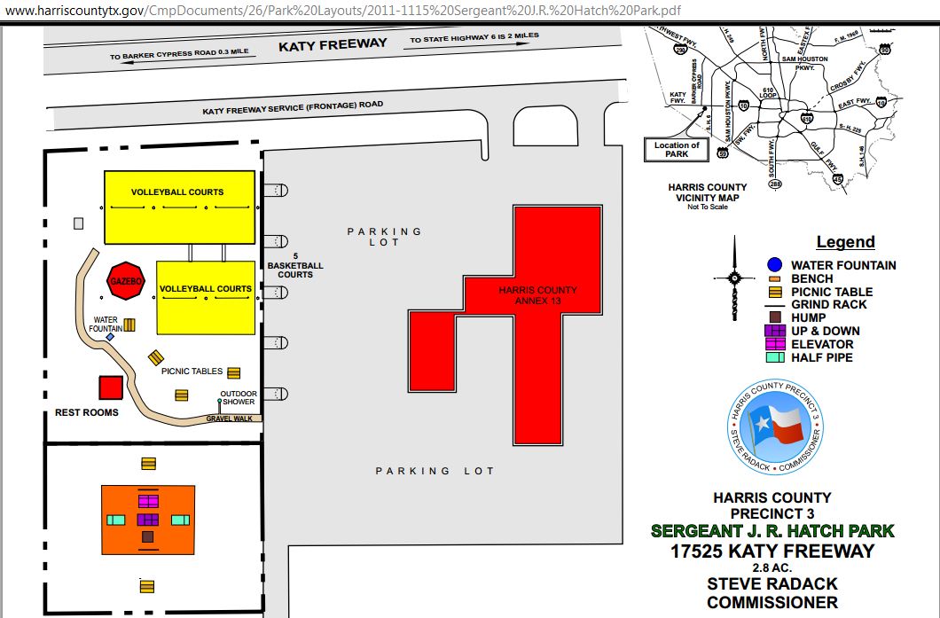
Layout of J.R. Hatch Park with features and facilities marked
(Click this link for full-size park layout pdf-file)

This park is not for little kids, though. It does not have an area with playground equipment. The latter can be found in Terry Hershey Park on Memorial, at Ray Miller Park on Eldridge, and at Cullen Park Phase 2 (Saums) and Phase 4 (South of Groeschke Road/West Houston Airport), and at Bear Creek Park (on the Eastern end near the animal pens, but on the North side of War Memorial Drive).   

Hatch Park can be accessed by car from Katy Freeway inbound feeder road, or by bicycle from the George Bush Hike and Bike Trail.  

Hatch Park in satellite view (with small Panoramio pic)

The concrete-clad east end of Barker Dam is located just South of the park. Those in need of more than just a leisurely stroll with fresh air can head out there, and put miles on their pedometer on the top of the dam. The trail at the foot of the dam seems to be the exclusive preserve of cyclists, and most of them do go fast. 
   

Barker Dam with Bush Park Hike & Bike Trail at its foot (looking West)
The George Bush Park Hike and Bike Trail passes here, then turns South, permitting cyclists to transverse the Reservoir on a closed road (Barker-Clodine) all the way down to the parking lot at Beeler North of Westheimer Parkway (Equestrian Trail parking lot) and the Rugby and Soccer Fields farther to the West. 

Trail Head on the North end of the North-South segment of George Bush Bike Trail
The North-South route through Bush Park passes the historical site of the former Marks LH7 Longhorn Cattle Ranch, with a Texas Historical Commission Marker, interpretive poster with background info on the Marks family and their longhorn cattle operation and old photos, a vintage homestead windmill, and a few historical buildings including a small church and what purports to be the erstwhile Barker General Store and Post Office. 

Country church on Marks Ranch grounds behind the wreath-adorned gate around X-Mas time
Legendary LH7 Ranch site with wind mill and Historical Marker today